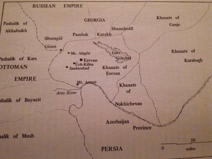
In the north, the khanate of Erevan bordered the Russian-administered districts of Shuragol, Pambak, Kazakh, and Shamshadil in Georgia [by 1812, almost all of historical Georgia was under Russian domination]; to the east, the khanates of Ganje and Karabakh; to the south, the khanate of Nakhichevan, the Persian province of Azerbaijan, and the Ottoman pashalik of Bayazit; and to the west, the pashalik of Kars. These borders were under the jurisdiction of the khante of Erevan for the last two decades of Persian rule.
Throughout its history, the khanate of Erevan was divided into various kinds of admnistative units. By the second decade of the ninetheenth century, the territory was organized into fifteen districts (mahal) – usually named after the rivers or streams that divided them – as follows:
Zangi-Basar mahal, which was an important population center, stretched from the southern portion of the city of Erevan and extended to the Aras River. Although in the eighteenth century it had been part of the Kerk-Bulagh mahal, by the nineteenth century it formed a separate district. Ulukhanlu (M. Masis) was the center for the twenty-six villages of this district. The district was watered by the Zangichay (M. Hrazdan) and by some of the Kerk-Bulagh streams directed through many man-made canals. Garni-Basar mahal was located west of Lake Gokchay and extended to the Aras River in the south. It was populated by many nomads and some Muslim settlers but had a few Armenian residents. It center, Qamarlu (M. Artashat) was surrounded by fifty-two villages. The Garnichay (M. Azat) waterway passed through the district.
Vedi-Basar mahal, situated on the left bank of the Aras, was encircled by the Sharur, Surmalu, Gokchay, and Garni-Basar mahals. It contained numerous nomads but almost no Armenian families. In the previous century Vedi-Basar had formed a part of the Garni-Basar district. The district had twenty one villages, with Davalu (M. Ararat) as its center. The Vedichay and Qapan streams were its major sources of water.
Sharur mahal, the southernmost district of the khanate, bordered Nakhichevan, and Persian Azerbaijan. Large numbers of nomadic tribes lived in the area, but no Armenians resided there. Formerly a part of Nakhichevan, this district was not incorporated into the khanate until the beginning of the nineteenth century. Its center was Engija (M.Ilychevsk), which oversaw fifty villages. The eastern Arpachay was its main irrigation source.
Surmalu mahal was located on the right bank of the Aras, between that river and the Aghri-Dagh Mountains. A very populous district, it had the largest number of nomads in the khanate. Its center, Igdir, was in charge of forty-nine villages surrounding the foot of Mount Ararat. It was watered by the Aras in the northwest; in the south, where there was pastoral nomadism, agriculture was marginal.
Darakend-Parchenis mahal, also on the right bank of the Aras, was the southwesternmost district and lay to the west of Surmalu. It was the main center of the Asni nomadic tribe. In earlier times it had been considered part of the Surmalu mahal, but Hosein Qoli Khan made it a separate district and installed an administrative apparatus to manage the important Kulb salt mines. A tributary of the Aras watered its fifty-five settlements, twenty-six in Parchenis and twenty-nine in Darakend, which had their administrative center in Kulb (A. Koghb; M. Tuzlucha).
Sa’adlu (Sa’otlu or Sahotli) mahal, the smallest in the khanate, was situated next to the pasalik of Kars, on the lands between western Arpachay and the Aras River. The Sa’adlu tribe dominated the district, which had no Armenian population. It contained only nine villages, with Kheyri-Beglu as their center.
Talin mahal, situated between Mount Alagos and the western Arpachay, bordered Georgia and was located on the main road connecting the two regions. The district was not a major population center, having only twenty villages. However, the important trade routes to the Black Sea and Russia, via Tiflis, passed through its center, Mastra and Talin (M. Verin-Talin).
Seidli (Seyyedli)-Akhsakhli mahal was located on the southeast flanks of Mount Alagoz. The Seidlu-Akhsakhlu tribe dominated this mahal, which had only a few Armenian families. It encompassed twenty villages (eleven in Seidli and nine in Akhsakhli) and had its center at Ushi (M. Artashavan), on the bank of a tributary of the Aras.
Sardarabad mahal was on the left bank of the Aras. The rural areas of this mahal were populated by a large number of Kurds, while the twenty-two villages had a mixed Armenian and Turkic population. During the rule of Hosein Qoli Khan, a fortress was built here, both to secure the traditional invasion route from Russia and the Ottoman Empire and to serve as a summer resort for the ruling members of the khanate. Some of the villages in the district were given in tuyul (“land assignment”) to members of the hierarchy, and its administrative center, Sardarabad (M. Hoktemberian), served as the second government seat of the Khanate of Erevan.
Karbi-Basar mahal (Karpi), a densely populated and rich district, was located in the very center of the khanate. The hierarchy of the Armenian church, as well as a large number of Armenians, resided in this region. The ecclesiastical center of all Armenians, the Holy See of Etchmiadzin (T. Uch-Kilisa), was located in this district, where it remains today. Surrounded by a stone wall close to 2,000 feet in circumference, it contained buildings with separate priests’ quarters which resembled a caravansary, and a garden surrounding the residence of the catholicos. A section reserved for animals and other church provisions was attached to the priests’s residence. There was a bazaar in the main courtyard with numerous shops for rent. The main monastery had three major gates: the Tiridates, the inner (nersi darbas), and the outer (dursi darbas). Etchmiadzin had seventy resident ecclesiastics and a greater number of lay employees. Other Armenian communities were in Oshakan, Eghvard, and Biurakan, all of which had large church holdings. The tax rolls mention forty villages, with Ashtarak as the administration center for the Persian bureaucracy of the mahal. The waters of Aparan-su (M. Kasakh) and Karbichay (M. Amberd), both tributaries of the Aras, were diverted into extensive irrigation systems.
Aparan (Abaran) mahal, the northernmost and also one of the highest districts, was close to the banks of Aparan-su. It had virtually no settled population of Armenians or Muslims since it was in the war-zone and directly on the invasion road from Georgia. The region was populated mostly by the Buyuk-Chobankara tribe. Its thirty-nine settlements, most of which belonged to the nomads and served as winter quarters or military garrisons, were administered from Bash-Aparan (M. Aparan).
Darachichak mahal bordered the territory of Georgia and extended to the northern tip of Lake Gokchay. Its mild climate made it an ideal summer resort for the elite of the khanate. This district contained thirty-seven villages, with their centers at Darachichak (M. Dsaghkadzor) and Bdjni. The area was watered by the Miskhan-su (M. Marmarik), a stream of the Zangichay.
Gokchay mahal, the largest district of the khanate, contained the freshwater Lake Sevan (Gokchay). Extreme climatic conditions and numerous skirmishes in the previous century, however, had depleted the population and attempts by the last khan of Erevan to repopulate it were not entirely successful. The area was generally populated by nomadic tribes and had few Armenian residents. It had fifty-nine small settlements, some populated by nomads during the winter. Their center was Gavar, sometimes referred to as Avan (R. Novo-Bayazit; M. Kamo). Gokchay mahal was watered by numerous streams, which formed in the highlands and emptied into the lake.
Kerk-Bulagh mahal, an important, centrally located district partly surrounding Erevan, was separated from the Gokchay and Darachichak mahals by the Aghmaghan Mountains and divided from the Zangi-Basar and Garni-Basar districts by the Zangi River. Its twenty-two large villages supplied Erevan’s daily provisions. Kanaker (Kanakir) served as its administrative center. The district was watered by the Kerk-Bulagh (Turkish for “forty streams”; M. Getar), a large stream with forty branches.
The Kameral’noe Opisanie lists 521 villages in the khanate of Erevan. This number represents the total inhabited villages after the Russian conquest and does not indicate the number of settlements during the long Persian tenure. Fortunately, the survey also recorded a large number of settlements that were depopulated or abandoned. The frequent wars, nomadic migrations, and natural disasters of the eighteenth and nineteenth centuries had obviously taken their toll. Most of these villages were soon repopulated by Armenian immigrants. After the incorporation of the khanate into the Russian Empire and throughout the remainder of the nineteenth century, they continued to arrive from Persia, other Transcaucasian centers, and the Ottoman Empire.
Source – Eastern Armenia in the Last Decades of Persian Rule (1807-1828), George A. Bournoutian, Undena Publications, Malibu, California, pp. 53-61


